Favorite California Waters: August 2009 Archives

Delta Stripers--Planning a Trip

| Comments

What's wrong in these photographs?

Bill's Striper.jpg

My bass.jpg

The answer, of course, is that I am the angler holding up the small largemouth caught on a plastic worm. My old friend, Bill DeWalt, proudly displays a hefty striper caught on a fly rod using a Clouser Minnow pattern that he had tied. While I doggedly preserved with my conventional gear hoping to catch a nice largemouth, Bill stayed the course with his fly rod. He caught a couple of small stripers and encouraged me to switch to fly fishing. I grumbled that I have fly fished my entire life, and I now wanted to fish with conventional gear. Besides, the fishing was slow, and I thought I had a better chance with my bait casting rig and a jig. Although I wished I was holding that big fish, I was thrilled that it was landed in my boat. I am now convinced that fly fishing for bass on the delta is a viable alternative to slinging hardware. I am also intrigued with the notion that largemouth bass rarely see a presented fly, unlike the constant barrage of spinnerbaits, crankbaits and plastic that drop in on them everyday of the season.

I traveled to the Sacramento-Delta this spring only to find myself in the middle of a cold-front. It occurred to me that fly fishing anglers from Montana undoubtedly would enjoy a fly fishing trip to the Sacramento delta. It is a wonderland of waterways. Built over 100 years ago to control the Sierra snow melt from the Sacramento River, the Mokolumne River and the San Joaquin River, the system claims almost a thousand miles of river, tidal lakes, sloughs and cuts. The delta has attracted the attention of tournament bass fishers for decades, and some experts predict that a world record largemouth bass could very well be lurking there now, especially with the introduction of a Florida strain of LMB. Striped Bass can be found in the delta year-around, but the migratory Striped Bass coming into the delta from the ocean and San Francisco Bay attract anglers from all around the region. The bass arrive in the spring for their spawning. By mid-June these migratory bass return to the San Francisco Bay and the ocean, but they return again in the fall. With so much water available, and so many fish, where would a new visitor launch for the first time?

The first step is to buy a map of the delta from one of the following sources:

Department of Fish and Game, Central Valley-Bay Delta Branch, 4001 Wilson Way, Stockton, CA 95205. (209) 948-7800. Go on line to view maps from the Department of Fish and game: http://www.delta.dfg.ca.gov/stripedbass/

www.frankomaps.com

www.fishnmap.com

I believe that the best chance for success, good camping, and the least chance of getting lost is to target one of the tracts, which were once farming tracts. Through the years flooding conditions caused major breaks in the levies flooding farmland and creating large lakes. One area that I especially like to launch from is B&W Resort, just across the Sacramento River from Rio Vista on High 12. For reservations call 916.777.6161 or email them at info@bandwresort.com. B&W does not have camping, but they let me stay in my camper in a parking area. I like this resort because it is close to Frank's Tract, the Sacramento River and the San Joaquin River. Continuing on Highway 12 east towards Lodi, Tower Marina has a KOA next door, and it offers good fishing for stripers and largemouth in the Beaver Slough, Hog Slough and Sycamore Slough area. http://www.towerparkresort.com/
It too is within reasonable distance to Frank's Tract. Another great destination is Mildred Island, which offers good fishing on the lake and all around the track.

Here are some links for further information

http://www.californiadelta.org/

http://www.fishsniffer.com/

http://www.deltastripers.com/

Lower Sacramento River

| Comments

Redding, California - Oct. 25, 2007
The Sacramento River from Redding to Red Bluff

walk-bridge.jpg

So where does a former Montana fly fishing guide residing in Chiloquin, Oregon get his float fishing river fix. Perhaps the nearby Williamson River, maybe the Rogue or the Klamath or even the Trinity, but my choice will probably be the broad, big muscled lower Sacramento River. Flowing from the Keswick dam at the outlet of Lake Shasta, the lower Sacramento River flows through the town of Redding on its way to the San Francisco Bay. Miles of prime trout habitat line both sides of the river all the way down to Red Bluff. Offering four separate salmon runs, along with steelhead, the trout are healthy and fat. According to Michael Caranci, director of outfitters for The Fly Shop in Redding, California, when the dam operators were required to control flows and water temperatures to protect salmon runs and salmon fry, the trout benefited, and the fishing gets better year after year. I met with Michael at The Fly Shop, which may be seen from I-5 just north of the Churn Creek Exit. With October being their busiest month, Michael estimated they would finish the month with close to 400 trips. In spite of the hectic flow of anglers asking to book if there were any cancellations and the phone ringing constantly, Michael took the time to describe and promote the lower Sacramento River. I was impressed, but then maybe that is the reason The Fly Shop was voted the "Top Shop" by the fly fishing industry in 2003.

flyshop.gif

Two of the most productive months of the year are April and October. March and April basically kick off the season with prolific hydropsyche caddis hatches. The "Mother's Day Caddis Hatch" bursts on the scene blanketing the air with millions of bugs on warm, sunny days. Michael said, "The trout gorge themselves and eat, eat, eat, but the problem sometime becomes too many of the real thing surrounding an imitation." The caddis continue to hatch throughout the season and into the summer during the last hour of the day, which provides some good dry fly fishing. Many guides, in spite of the hatches, continue to fish under the surface with sparkle pupas, peeking caddis, Bird's Nest or bead-head nymphs in size 12 to 14, along with smaller emerger patterns. In May sporadic "hatches" of salmonflies appear through out the system but not on a predictable basis. Each year the salmonflies presence in the river grows.

driftboat.jpg

With rising temperatures of summer often exceeding 100 in July and August, the pressure of anglers on the river wanes, but the fish continue feeding in water temperatures from 55 to 60 degrees. I met a preacher working on his sermon on his tailgate at the Bonnyview Bridge near the water's edge. He said he liked fishing from his kick boat during the summer. With his legs submerged in cold water and his torso absorbing the hot rays of summer, he said he experiences heaven and hell in the same moment. He told me to emphasize to readers that sitting this close to the water was actually about ten degrees cooler. He said he keeps himself hydrated with lots of water and very busy with good fishing. Typically, however, the first and last hours are the most productive fishing of the day. By late August the nights are cooling and day time temperatures began dropping to the nineties.

waders-bridge.jpg

By September the first salmon runs appear. By October the salmon are busy building reds and kicking up debris and dislodging nymphs. The trout move in behind the spawning beds and feast on nymphs and the loose eggs that get washed downstream. Michael described it as "salmon omelets." Michael advised me to be especially vigilant when wading so as to not disturb or destroy the beds, which are easily identified by the light-colored depressions in the gravel. One successful technique to employ during October is a strike indicator, lead split-shot, a single egg pattern and one or two nymphs.

sac-setup.jpg

In spite of the increased pressure during October and November, guides spread themselves out over seventy miles. Michel stated thattypically by Thanksgiving or earlier the rains sweep up the valley and blow the river out below Cow and Cottonwood Creek, but it is rare that the upper stretch will be gone for more than a day or two at a time. That is actually one of the big assets of the Lower Sac, that it remains a viable fishery almost all winter long.". Most anglers wait for spring, but Michael pointed out that late winter on the lower Sacramento River offers good fishing between storm fronts. The latter part of the winter does not have the impact on water flows that November and December experience. Although air temperatures hold in the 50's and 60's and the fish slow in their feeding activity, more larger fish in the 18-inch range are caught during this time period with an added bonus of late winter baetis hatches. By early spring trout are gorging themselves on alevin, salmon fry, and gaining up to one pound a month from these tiny fish with the egg sacks still attached. If there is a dry fly period, it is in March and April when the caddis return and a new season is heralded.

To contact Michael and book a trip with The Fly Shop, you may reach him by phone at 1-800-669-3474 or at Michael@theflyshop.com or www.theflyshop.com

Launch Ramps and Access Points: Keep in mind that the time of year and the water levels flowing out of the dam determine whether wading is a viable option. Because the current is so strong, I recommend inflatable suspenders and a wading staff. For a detailed guide to the river, I recommend that you purchase the map, Sacramento River Fishing Access & Accommodations. The map may be purchased at The Fly Shop in Redding or by visiting their web site at www.streamtime.com. I welcome all scrutiny, corrections and advice, as this article will be a work in progress over the next year. Contact David Archer at dave@glaciertoyellowstone.com

2007 Shuttle Fees from The Fly Shop:
Posse Grounds as far as Sacramento RV Park...$25
Posse Grounds to Anderson...$30
As high as Bonnyview to Balls Ferry...$35
As high as SAC RV to the Barge Hole (Balls Ferry road near old mouth of Battle Creek)
...$40
As high as Balls Ferry to Jelly's...$45
As high as Balls Ferry to Bend Bridge...$50
Add map 1

posse-launch.jpg

map1.jpg

1. Posse Park Boat Launch + Wading: From I-5 take Highway 299 West and make a right onto Auditorium Drive (convention center). You may also reach the Posse Grounds from Cypress Street by turning north on Park Marina Drive, which ends at the convention center. This is the first launch past the A.C.I.D. Irrigation Dam a couple of miles below Lake Shasta's Keswick Dam. The launch site is behind the rodeo grounds near the convention center and provides good parking for all sized rigs and excellent access to Posse Riffle, as well as the numerous riffles and runs down to Redding's famous Sundial Bridge. During low water periods in the fall, wading anglers have numerous hot spots they may reach in a half mile stretch below the launch. During the summer months the numerous shaded, picnic spots provide welcome relief when temperatures climb to three digits. Turtle Bay Trail, across from the convention center and downstream from the launch, also provides access.

warn-sign.jpg

Two of Redding's bridges are under construction for the next couple of years. The river has restricted passages in two places.

cypress-restric.jpg

cypressbridge.jpg

2. Cypress Street Bridge Area: Exiting from I-5 onto Cypress Street in downtown Redding, move to the left lane and turn left on Hartnell at the light just short of crossing the bridge. This is a business section. Make the first right turn onto Henderson. Look for the sign "Road Ends 400 feet ahead." Turn right here and drive behind the businesses and park. Take the dirt path towards the Cypress Street bridge or turn downstream fifty yards and fish the riffle and pool by the old bridge abutment. This is a popular spot for the float fishing guides before they cross over and fish the western bank of the river. Crossing the bridge, anglers will find some water above and below the bridge.

bonnyview.jpg

3. South Bonnyview Road (Bridge) Launch: This is an excellent boat launch and parking area, although it doesn't provide good water for fly fishing in the near vicinity. From Posse launch to South Bonnyview is a half day float.

4. Cascade Park: Exit I-5 west on South Bonnyview Road. Turn left on Market Street or Highway 273 and then left again on Girvan and proceed a short distance to Cascade Park. I did not get far without waders. The park is adjacent to islands, although the channel was very shallow. South of the park is Niles Riffle, but I never made it - another time.

map2.jpg

5. Anderson River Park (launch): This is another spot that I missed. The Fly Shop provides maps to local wading spots, and this is one of them. South of Redding on I-5, take the Deschutes Road Exit (Factory Outlet Stores). Go west and turn left (north) on Balls Ferry Road and then right on Dodson Lane to Anderson River Park. Follow the trail down river for good riffles. An improved boat launch is located on Rupert Road, which may be accessed from a loop off Dodson Lane.

deschutes.jpg

6. Deschutes Road Bridge: From I-5 take the Deschutes Road Exit a couple of miles east to the Deschutes Road Bridge.

7. Balls Ferry Bridge (Bridge) Launch: From I-5 take the Gas Point Road Exit and follow Balls Ferry Road until it intersects with Ash Creek (sharp corner). Follow Ash Creek about a mile to the boat launch. (The bar here serves a good burger.) It is five miles to Cottonwood, a quaint little town close to I-5.

8. Reading Island: From I-5 take the Gas Point Road Exit and follow Balls Ferry Road until it intersects with Adobe Road. Turn right and proceed to the parking area less than two miles. Maps are not always accurate; the public campground has been closed by the county, and the launch is only good during high flows onto a side channel, and even then for smaller boats. Now, I did talk to a lady who lived close by and was walking her dog. She said she often sees fly fishermen casting on the main stem a short distance from the parking lot.

9. Old Mouth Battle Creek (Launch and primitive camping): The primitive camping is just that - primitive and rocky! Look for a drop off onto a dirt road. There are a couple of water holes to cross, but they are solid underneath. Nonetheless, after a rain this could be a potential mess without four wheel drive. The beach is hard packed cobblestone, and during October it is a popular spot for local salmon anglers (especially during the weekend). It is also a launch for boaters heading up to the Barge Hole just upstream. This section offers a beautiful riffle that left me frustrated and perplexed. I chalked it up to a full moon - not my skills! I talked to two neighborhood river watchers who said that during the caddis hatches the riffle comes alive with trout just at dark. From I-5 take the Jellys Ferry Road, cross the bridge and continue until you crest a plateau and see the river stretching out below you. From the crest, some anglers hike down to the river and fish Lawrence Riffle. As you drop off the crest down the slope, you will see on your left a long beach with a primitive boat launching spot. Just ahead on the left in the trees is the turn-off to this primitive site.

jellys.jpg

10. Jellys Ferry Bridge (Launch): From I-5 take the Jellys Ferry Road to the bridge and parking area and boat launch. (No camping.) This is a rough boat ramp; during low water periods you will be launching in wet sand and mud. I would recommend 4x4 vehicles after a rain. The site is run by the Department of Interior, but it does not allow camping.

bendlaunch.jpg


11. Bend Bridge (Launch): From I-5 take the Jellys Ferry Road Exit. Turn right on Bend Ferry Road by the Bend RV Park (916-527-6289) and store and cross the bridge to a county launch site. Fish the Lower Bend Riffle or take the trail on the north side of the parking lot to riffle water upstream.

bend-fence.jpg

bend-riffle.jpg

RV Camping Parks

jgw-rv.jpg

JGW RV Park: The JGW RV Park is located on Riverland Drive on the west side of Interstate-5, south of the Knighton Road exit. Exit 673 is approximately five miles south of Redding. (530) 365-7965. Reservations: 1 800-469-5910. www.jgwrvpark.com. Email: jgwrvpark@charter.net. (In the north corner of the park is a 5-strand, barb-wire fence. Go around it at the river's edge and walk upstream 100 yards to a great riffle, where I met a couple of fat rainbows. The resort provides a rough boat launch.

sac-rv.jpg

Sacramento River RV Resort: The Sacramento River RV Resort is located on Riverland Drive on the west side of Interstate-5, south of the Knighton Road exit next to JGW RV. Exit 673 is approximately five miles south of Redding. (530) 365-6402. www.sacramentoriverrvresort.com. Email info@sacramentoriverrvresort.com. Beautifully shaded, the resort offers a concrete boat launch for high water conditions and a dirt launch for low water conditions. Launch fees for non-guests is a bargain $3.

Marina RV Park: The Marina RV Park is located at 2615 Park Marina Drive. Although it is not a park like setting with lots of shade, it is within walking distance to restaurants and movie theaters. The launch fee for non-guests is $22.


Upper Sacramento River

| Comments

One of California's Best Freestone Streams

Use3.JPG

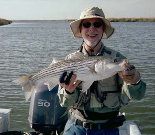
About 35 years ago while I was attending Sonoma State College and residing in Santa Rosa, I picked up the San Francisco Chronicle and read Jim Freeman's outdoor column. He had just returned from a fishing trip on the Upper Sacramento River, and he outlined his success on the river fishing with Ted Fay, a Dunsmuir angler and fly tier who had gained a reputation as one of the most knowledgeable anglers on the Upper Sac. Black and brown weighted Woolly Worms and Woolly Buggers in tandem dabbed and dropped along the sides of boulders both submerged and rising above the water column were tactics that produced then and will produce today. The next weekend I rushed up to the Upper Sacramento River to Dunsmuir and located Ted Fay's home. Ted was on the river fishing, but his wife invited me inside. I asked if I could buy a few of Ted's flies. The small living room was cluttered with fly tying equipment and supplies. In the center of the living room was an "Archie Bunker" chair with a table and vise which faced the television.
"Do you know what pattern, size, color that you want?" his wife asked.
"No," I replied. "I only know how to fish with dry flies. I'll just take whatever you recommend."
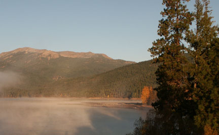
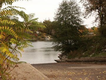
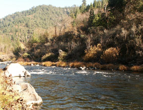
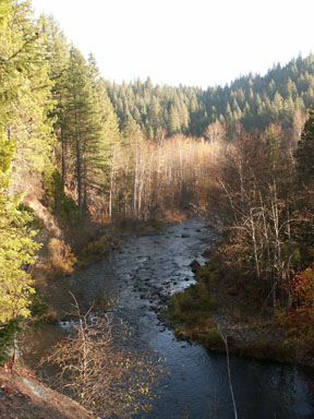
"Well, I would recommend whatever he has left next to his vise. That's what he will be using today. When I returned home, I immediately ordered a Thompson vise and supplies from a Herter's catalogue, and along with a book on fly patterns began copying my few remaining Ted Fay flies. With the river's recovery after the infamous chemical spill by the railroad in 1991, I could find little change. What I did find was beautiful stretches of a small, freestone stream that stretches almost thirty-five miles from Lake Siskiyou to Lake Shasta. The only difference I experienced was my own difficulty in wading and scrambling down embankments. When I see men in their 70's out in the middle of a rocky-bedded stream, I sigh with resignation uncertain if I will be able to do the same in ten years.

use4.JPG

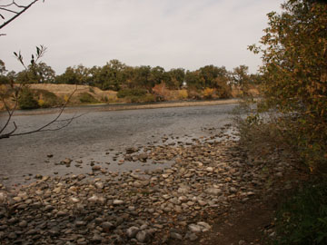
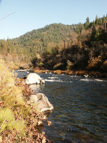
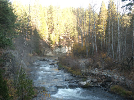
Although I trekked up and down the river in November and managed to catch a late afternoon caddis hatch and some lone giant October Caddis which put the little fish on the bite, most authorities recommend waiting for spring run-off to subside, noting that late May and June are the early summer kick-off months for fishing the Upper Sacs riffles, runs and beautiful pocket water. Considering the vagaries of snow melt and arrival of insects, anglers in the early summer months are typically greeted by hungry trout and plentiful hatches of stoneflies, caddis and mayflies. Wading in November, my cold, numb feet reminded me that the river is a tailwater, freestone river, and the water that comes out of the lake and drops down into the dark canyon remains cold, in spite of the balmy 70-degree air temperatures. The river also gains more volume of water from tributaries before it meets the lake.

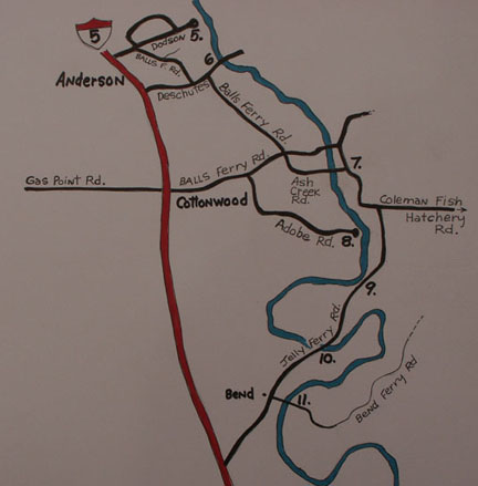
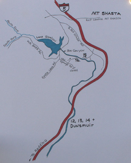
With the help of the Shasta /Trinity Forest Service website, and the StreamTime map, Upper Sacramento River Access, I was able to discover numerous good access points right off Interstate 5. The Forest Service website also offers a hatch chart with suggested patterns courtesy of The Fly Shop. Almost every exit off the interstate leads to good fishing waters. I have included most of these exits. The fishing map can be purchased at Ted Fay Fly Shop in Dunsmuir or The Fly Shop in Redding. Ted Fay Fly Shop's new address is 5732 Dunsmuir Ave., Dunsmuir, CA 96025, or they may be reached at (530) 235-2969. www.tedfay.com.

http://www.fs.fed.us/r5/shastatrinity/recreation/st-main/st-fishing/rivers/upper-sacramento.shtml


Access Points Northbound on Interstate 5 from Lakehead to Box Canyon Dam above Dunsmuir

map1-usac.jpg

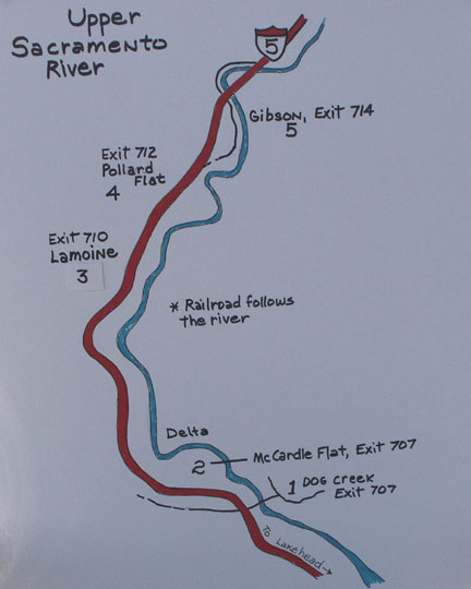
Note: Much of the phrasing for directions is taken directly from the forest service website, which is not copyrighted.

1. Dog Creek: Traveling I-5 Northbound, take the Vollmers exit #707. Turn left on Dog Creek Road/Delta Road, and go under the freeway. Travel 0.3 miles and turn left on Fender Ferry Road. Travel approximately one mile down Fender Ferry Road under the freeway bridges, cross railroad tracks and cross a one-lane bridge over the Sacramento River. Park along road after crossing bridge. Walk down the dirt road to the right for river access. You will find some long runs and slow pools during low water.

2. McCardle Flat: Take Vollmers exit 707. Turn left onto Dog Creek Road/Delta Road. Turn right on Delta Road, then turn left onto McCardle Flat Road. Travel 1.0 mile down McCardle Flat Road and turn right onto a gravel road. Go approximately 0.4 miles down the graveled road and park in widened area near railroad tracks, or you may take the dirt road to the right that leads to a parking area downstream with a turn-around and a primitive spot for camping. (The railroad track is very close for those of you who are light sleepers or have sleep disorders!)

3. LaMoine: Take the LaMoine exit. Travel 0.5 mile and turn left at first dirt road (across street from school bus sign on right). Dirt road forks, take right over bridge (Slate Creek). Travel approximately 0.2 miles on dirt road and park along road at top of hill. Walk down the dirt road to the left and head east to the river.

angler-red.JPG

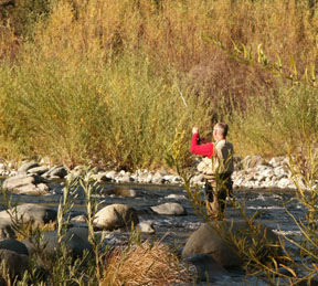
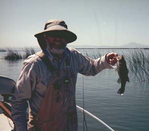
I watched this angler catch two small trout in less than ten minutes on a small dry fly.

4. Pollard Gulch: Take Pollard Flat exit. Turn right at the stop sign. Turn left on Eagle Roost Road. Take an immediate right and follow to a parking area for seven vehicles (Note: No parking spaces for large RVs or trailers). This is a USFS picnic and day use site.

5. Gibson: Take the Gibson exit #714. Follow the road as it circles over the freeway heading south; the road parallels the freeway heading south, then goes east under the freeway, and then parallels river. Park along Gibson Road and walk to river. The further the road heads south, the higher the road is from the river. If you continue, it will meet up with the Pollard Gulch access.

simsbridge.JPG

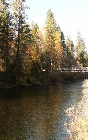
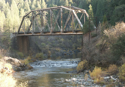
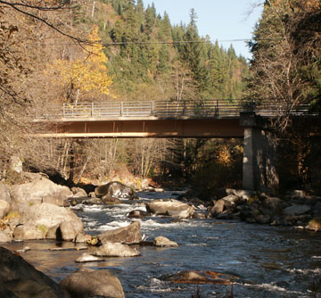
Sims Footbridge, a Civilian Conservation Corp project

map2-upsac.jpg

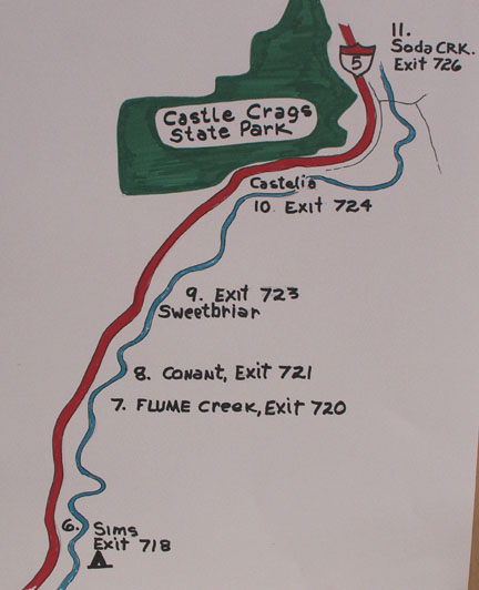
6. Sims: Take Sims exit #718. Turn right on Sims Road. Cross railroad tracks and bridge over Sacramento River to a parking lot near a pedestrian bridge. The Sims USFS campground is beautiful and right on the river. The cost per night is $12, but the daily fee will rise to $15 for the 2008 season. The campground closes on the last day of the general fishing season, November 16. I really liked this old campground, but just at the base of the hill is a dirt road that leads back to some railroad land and a primitive camping area with shade. Hey, when you are retired, these are the spots I look for to camp. Right across the tracks is a mini rock gorge, and above it is some nice riffle and run water. (I had some smaller trout torment me here.)

abovesims.JPG

7. Flume Creek Exit: Just before Flume Creek Exit #720, is a large pull-out just off Interstate-5. Follow the open gated road down the hill and downstream along the railroad tracks to Flume Creek. This area offers some great fly fishing water downstream, but I never checked upstream.

8. Conant: Take Conant Road exit 721. Turn right on Conant Road. Turn right at first dirt road. Park on the west side of railroad tracks. Walk east to the river.

conantbridge.JPG

9. Sweetbriar: Take exit 723. Trailers and RV's are not advised on this paved road. Do not cross the one-lane bridge. Park before the bridge. Here is a community that is open to sharing their section of water as noted on a sign. Personally, I wouldn't feel comfortable fishing with someone peering down at me from a deck as I muffed a cast or slipped on a rock.

10. Castle Crags State Park: Take the Castella / Castle Crag exit #724. (Chevron gas station) The state run campground is open year-around on a self-register payment system of $15 per night and $6 for day use parking. It has sites that will accommodate 27' RV's and 24-foot trailers, as well as tent camping. During the summer it can be filled up. For reservations call 1-800-444-7275. The park also has a picnic site across the river. Late in the fall there is not much water here, but in the summer it supposedly fishes very well. Fork up the six bucks because there is no other parking at the picnic site.

11. Soda Creek: Take the Soda Creek exit #726, about 2.5 miles below Dunsmuir. I had two friendly residents of the area direct me to Soda Creek. This was especially heart felt since I had a local give me the "Kiss-my-ass" gesture when I was exiting Scarlet Way! Since I was stopped, I was puzzled by his animosity. Was it the Oregon plates? Well, there are assholes everywhere that don't want to share. I will remember the two people who gave me unsolicited fishing tips - thank you, guys. Park in the dirt pull-out just before the bridge. Walk downstream past the chained fence and follow the path to a curve in the river that offers a big pool up against a cliff at the base of a riffle.

map3-usac.jpg

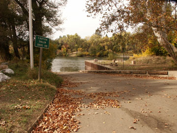
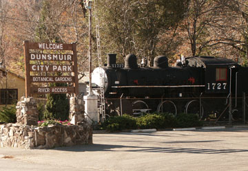
12. Dunsmuir City Park: Traveling I-5 Northbound, take Central Dunsmuir exit. Turn left onto Dunsmuir Avenue. Travel 0.5 miles and turn left at "Dunsmuir City Park" sign. Follow the road down to the park. Note: The town of Dunsmuir offers numerous access points to the river such as the I-5 Pool and the access at Financial Avenue. Tauhindauli Park is in central Dunsmuir and a paved road leads down to the water. No RV's, buses or semi-trucks allowed. (This is close to Ted Fay Fly Shop.)

DunCityPark.JPG

13. Scarlet Way, Dunsmuir: Take Central Dunsmuir exit. Turn left onto Dunsmuir Avenue. Travel 0.8 miles and turn left on Scarlet Way. The road sign is easily missed, but you will see the brass metal sign for Shasta Retreat that arches over the road. Turn right on Cave Avenue. Cross river and railroad tracks, turn left after tracks to dirt parking area. The road here is narrow and winds through a neighborhood.

14. Prospect Avenue, Dunsmuir: From the northbound lane of I-5, take the Dunsmuir Avenue exit #732. Turn left at the stop sign. Travel 0.3 miles and turn right on Prospect Avenue. (Look for the Prospect Avenue Fishing Access sign.) Turn right when the road forks and proceed to the bridge and the parking area. (Narrow road.)

Dunsmuir.JPG

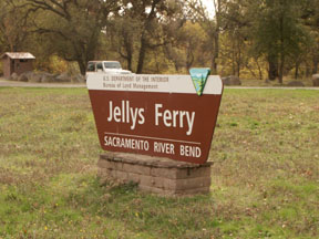
15. Cantara: To locate the Cantera Fishing Access area, exit from I-5 at Central Mt. Shasta. Turn left at the stop sign on Lake Street and proceed over the interstate until it intersects Old Stage Road. Travel 2.5 miles and cross Azalea Road, veering right to continue on Old Stage Road. Travel 0.25 miles and turn right on Cantara Loop Road. Follow the dirt road down some switch-backs to the dirt parking area. (Picnic area) Note: Just as you are descending down the road, you will note a road on the left with an open gate and no restrictive signs. This rough road leads down to the railroad bridge in a picturesque meadow. A commemorative sign acknowledges all the efforts that went into the clean up and restoration of the river after the chemical spill that took place in the vicinity. I found a nice unimproved campsite with no restrictive signs, but don't tell anyone I said you could "park" for the night. This is a beautiful area, and if you are cautious and wary, you can hike the railroad tracks upstream or downstream to reach less pressured areas of the river. Keep in mind, however, that some of the bridges and narrowing restrictions provide no escape for old farts like me who stumble along watching their feet. When you are my age, you have to hark back to kindergarten warnings: stop, look and listen!

NewSpringsRD.JPG

16. Ney Springs: Although the forks of the Upper Sacramento River above Lake Siskiyou offer small fish in small water, for all practicality the Upper Sacramento River is considered to be the outlet of Lake Siskiyou as it plunges out of the lake and down into the steep Box Canyon. The basalt gorge is, practically speaking, impassable. A couple miles down this twisting 100-foot steep walls of rock is the first access to the river. Ney Springs, with its cold water pulled from the bottom of the lake and its infusion of cold spring water, offers a prolonged mayfly hatch during the summer. Conversely, in the fall more optimum water temperatures may be found below the town of Dunsmuir. To locate the Ney Springs access area, exit from I-5 at Central Mt. Shasta. Turn left at the stop sign on Lake Street and proceed over the interstate until it intersects Old Stage Road. (Directly ahead is a fish hatchery.) Turn left on Old Stage Road and then veer right on W.A. Barr Road and cross over Box Canyon Dam. In less than two-tenths of a mile, turn left on Castle Lake Road. Take the first available left turn on a dirt road and travel 1.25 miles, and then turn left at sign that reads Cantara / Ney Springs Wildlife Area. The dirt road is narrow and leads down through a series of switch-backs. (No camping restriction)

Ney2.JPG

General Fishing Regulations 2007:
Open last Saturday in April to November 15
Zone 1: Dam to Scarlet Way in Dunsmuir; zero trout, artificial lures, barb less hooks
Zone 2: Scarlet Way to Sweetbriar - 5 trout, no special gear
Zone 3: Sweetbriar to Lake Shasta - 2 fish, artificial lures, barb less hooks

Zone 2 and 3 are open during the winter with zero limits, artificial lures only and barb less hooks.
Please read current regulations for any changes or restrictions.

Hey! Yes, you! I'm writing all this stuff and wondering if anyone actually reads it. I'd love to get some feedback on any of my articles. Email dave@glaciertoyellowstone.com. Thanks!

lake-siskiyou.JPG