Favorite Oregon Waters: August 2009 Archives

Brookings, Oregon and Gold Beach (Rogue River)

July 26, 2007 "I am not Worthy!"

dock.jpg

Creeks, streams, rivers and lakes beckon me, but of late the Pacific Ocean whispers promises of bigger water and bigger fish. My growing fascination for ocean fishing caught me by surprise. Bloody bait and endless trolling never appealed to me, but in truth, it is fishing that requires more patience than what I could have endured in my younger years. Had the label "Attention Deficit Disorder" been around during my school days, I certainly would have qualified. It is not that I elevate trout fishing or bass fishing above bottom fishing or salmon fishing, it is simply that the former both offer continuous casting and mobility. As I grow older, however, the appeal of trolling and catching a large salmon prompted me to head for the coast to investigate this logical extension of my angling experience.

driftboat.jpg

Living only four and a half hours from the coast, the allure of salt water fishing began with my first crabbing excursion on the Charleston Bay last fall. Had it not been for my wife noting that many of the crabbers were out trolling for salmon in between checking on their pots, I would probably still be concentrating my efforts on bass and trout. However, like all new endeavors specialized equipment and new skills have to be learned. The learning curve for conventional bass fishing was tough enough after a life time of fly fishing for trout. Ocean fishing will be a commitment of money and time, as well as learning boating safety. With that in mind, my first stop was Brookings, Oregon where I could prowl the docks while my wife visited her sister.

My first mistake was to purchase a rod and reel from a woman in the fishing department at Bi-Low in Grants Pass. Before you howl in protest at my seemingly sexist or chauvinist leanings, let me explain. I wanted a sales person who was an old sea dog, someone with real ocean fishing experience. When a woman stepped forward to help me, I tossed out a quick "sizing up her experience" question on salt water fishing. The question went directly to my task at hand, "Do you sell salmon rods and reels?" Quick to push down any further judgmental queries, I ended up walking out the door with an 8.5 foot Ugly Stick and an Abu Garcia level wind reel. Certain that I would be gouged in the tackle shops along the coast, I choose to save money and buy from an inexperienced sales person who answered my question with, "Yes, here is a popular reel."

"Penny saved, pound foolish" echoes in the recycle bin of my memory bank. I had purchased a popular river rig for salmon and steelhead fishing. The rod was too long for bringing a salmon to net while in a rocking boat out in the ocean, and the reel was too small for the minimum 300 feet of line required out in the ocean. My 18' skiff was not in compliance with the Coast Guard requirements. I did not have a proper throwable PFD. I did not have a VHF marine radio, nor did I have a magnetic compass or sound producing device, not to mention a visual distress device. I was only going to venture a mile out and test the boat I reasoned. I also noted that most small boat anglers had a back-up trolling motor. I cancelled any notion of just going out past the jetty to test the sea worthiness of my boat. I was not sea worthy. I also discovered that I need to take an Oregon test on safe boating procedures. I tried to book a bottom fishing trip, but the ocean was too rough so I headed up to Gold Beach to fish the mouth of the Rogue River for the first salmon arrivals for the fall run.

The owner of Rogue Outdoor Store in Gold Beach, Jim Carey, makes his living with repeat customers, both local and from out of the area. Like any good fly shop or tackle shop owner, Jim makes his living passing on information, providing instruction and helping people get set up properly. If he isn't too busy, he goes out of his way to help beginners, which in my case included setting up my rod when I showed some confusion on how to set up a sliding spreader and a Rogue Bait Rig by Luhr-Jensen. Designed for a 4" to 6" anchovy, the main line attaches to a spreader rig. The spreader rig is a V-shaped springy steel contraption that separates the dropper line and sinker from the running line to the bait rig. Jim set me up with a Glide-O spreader. The simple practicality of this rig is that if you tangle while playing a fish, the main line runs free. Since the spreader has a drop leader on lighter pound test line to the weight, the weight can be broken off without the loss of the fish. Additionally, the fish do not feel the weight when they take your bait or lure. From the second tip of the V- spreader the line extends 40 to 50 inches to a swivel. Below the swivel are a rotating blade and a single hook on a slip knot. The single hook adjusts to the baitfish length and body bend for correct rolling action. The single hook is threaded up under the jaw and extrudes out of the mouth. Jim told me that a good bending angle for an anchovy is the natural bend of your leg just above the knee. Using a slender, rigid wire with a notch at the end, the wire is pushed up the anus until it exits the mouth. The wire is notched on the terminal end of a perfection loop and then pulled back out the anus. A treble hook is then attached with one of the three hooks sunk into the flank of the anchovy just above the tail. Jim may be reached at Rogue Outdoor (541-247-7142) or online at www.rogueoutdoor.com.

old-pram.jpg

The next morning I headed to Lex's Landing to launch my boat for $5 and wolf down a breakfast burrito, which was delicious. I learned a lesson pulling a camper and a boat. It was an invaluable lesson if you travel to fishing grounds with a non-angling spouse. Pay for a mooring spot so you can head out early in the morning and not disturb your wife! I trolled for three or four hours dodging boats coming at me from all directions. Standing on the levy the previous day, it looked like the boats, for the most part, were traveling in an elliptical orbit in the same direction. When I got on the water early in the morning I had a half mile between me and the next boat. By nine o'clock I counted close to forty boats. By eleven o'clock my wife and I counted close to 60 boats, and I could detect no discernable pattern. By noon the coast guard was herding the small boats back into the safer water. Although I didn't have any action, it was a good trial run for later.

Fishing tip: Jim Carey recommends an Oregon blade, which is made locally. Information may be found at oregonblade.com.

coastGUARD.jpg


Dave Archer


August 1, 2007

Sid-Fish.jpg

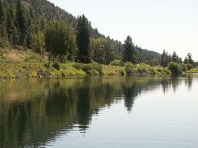
Our targeted hatch, often misidentified as a Green Drake or a Pale Morning Dun, was the genus, Emphemerella, the species doddsi. Leisurely gliding down the Williamson River in south-central Oregon, the dark green waters silhouetted the unmistakable sails of mayflies, but we were on a mission to locate the doddsi and test Sid's latest nymph pattern. Pushing on to the frog water, Sid gently rowed his drift boat while scanning the river ahead for the chameleon of Mayflies. I would learn that the doddsi posed a serious challenge to fly tiers in that within an hour of breaking through the surface and transforming to a dun, the body would take on an entirely new hue from yellow to dark, mottled green or a greenish brown. Large fish were nudging the surface and sucking down a variety of mayflies. Although the sippers and boiling trout quickened my heart rate, Sid, impervious to the obvious potential to cast to fish forty feet from the boat, kept his attention on the water. "There's one, no two," he exclaimed. "Up against the opposite bank just below that log. OK, let's see how long they drift before being gulped for breakfast."

I looked across the river straining to see the bugs that he was watching. "Yes, I see one I proudly concurred."

"Gone! Look at that boil. That was a nice fish," Sid said.

"Well, I saw the rise, I saw the boil, but I am confused because I still see the bug floating unmolested," I replied.

Sid turned and looked at me. Noting that I was squinting through my glasses he asked, "How many bugs did you see floating?"

"One," I replied.

"What you were looking at was a Hexagenia limbata, about five times the size of a doddsi."

Hex.jpg

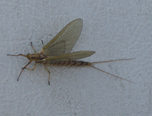
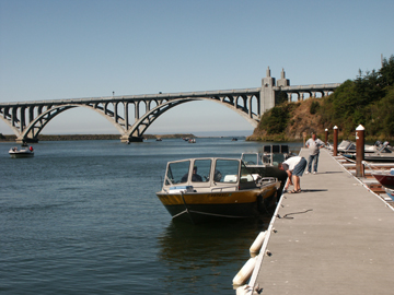
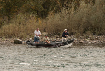
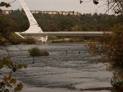
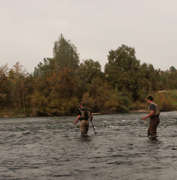
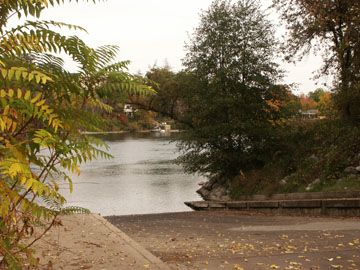
"No wonder I could see it," I mumbled. Later we would catch a Hex, and it would measure a full inch from the head to the end of the abdomen. Although typically emerging at dusk and into the night, we observed numerous Hexagenia drifting along with the doddsi. I was floating on a world class trout river famous for its huge trout with a quintessential world class fly fishing guide, Sid Mathis of Free Spirit Guide Service in Klamath Falls (541-884-3222). Earlier in the year I had asked to interview Sid, and now here I was in his drift boat watching Sid catch and release Klamath Lake rainbows on a beautiful section of the Williamson River. The only floating section on the lower river stretches no more than three miles from the county boat launch just outside of Chiloquin to the Wagon Wheel Campground below. Unlike the freestone rivers of Montana that I guided on, float fishing the Williamson River is akin to stillwater fly fishing. We anchored in one small area for two hours. During that period I would estimate that I saw between forty and fifty rises. When we drifted further downstream, Sid had me hang over the bow and count the trophy size trout darting out of the shadow of the boat. In two holes, within a forty yard stretch, I counted over twenty fish, weighing two to five pounds. Awestruck, I took my seat, opened up my briefcase and took out pen and pad along with a tape recorder. Earlier I had explained that I wanted to write a good article on fishing the Williamson River and Klamath Lake. I wanted to avoid the glib generalities that I had encountered in numerous articles that I had collected, and I wanted to gather this information from an authoritative source.

Q: How long have you been a guide, and did you have a mentor to help you launch your career on this challenging water?

Sid: I started fly fishing in 1976. By 1978 I had adopted the principle of Catch-and-Release. In 1980 I learned from an inside source that they were going to shut down the mill that I worked at. I had been running shuttles for Rich Henry, a Native American and local guide on the Williamson River. Rich grew up in the Beatty area and began fly fishing and fly tying in the early 70's. He was a great caster and an innovative tier. He asked me if I would be interested in guiding for him when he had more bookings than he could handle. I got the overflow, but I soon discovered that I had clients that would bring along a thousand bucks worth of flies and argue with me if I tried to steer them to one of my favorite patterns. Although I knew what I had was a better offering, I didn't have the experience or knowledge to change their minds. When my clients persisted in using poor fly selections and didn't catch any fish, I knew I had to master my craft. I went to Rich and told him that if I was going to continue as a guide, I had to do it right and master this new career.

I asked Rich if he would teach me all that he knew. Rich took a long pause before answering. He reminded me that he made his living guiding and that to take me on as a student would cut into the days he could otherwise spend on the river guiding fly fishermen. I pressed him and asked him how much he wanted. I would need $25,000 he said. That was a lot of money in 1982, and I was at a loss of words. I told him it was a lot of money for a year of tutoring. He replied that it would take maybe three years. I agreed to pay him half at the beginning and the other half when he felt I was done. I won't describe my wife's reaction, but after 27 years of guiding, I never spent $25,000 on anything as valuable as those three years studying under Rich Henry.

Q: Is he still alive? What was he like? What was your training like?

Sid: Yes, he is still alive. He lives in Brookings, Oregon. Although the fly fishing community doesn't know much about Rich, the fly fishing gurus know Rich Henry. Rich is a kind-hearted man, a conservationist. He is a short, muscular man with broad shoulders, big arms and enormous hands. How in the world he could tie a fly on a miniscule #32 hook is beyond me. When he took me on he made me swear never to kill a fish intentionally and only use primary sources for my aquatic entomological research. Rich placed the most emphasis on aquatic research, learning all about fish food. We would go out on the rivers and the lake and gather specimens to bring back to Rich's trailer and identify. I learned about environmental factors that influenced the hatches. Then I learned how to identify nymphs by their swimming actions, and where and when they hatched, and we studied the insect migrations. It was as intense as any college program, but like many students I got myself in trouble.

The intense studying and note taking and cataloguing my drawings became tedious. One day when we were in the field, I spouted off some information that I had just read in a book. Rich looked at me quizzically and told me to finish up my sampling and then he wanted to talk to me back in his trailer, which was not too far from the river. I had no idea what he would want to talk to be about back in his trailer rather than there on the river bank. When I got back to his trailer, he had a serious look on his face, and I knew that somehow I had made a mistake. He asked me if I had been reading secondary sources. I admitted that I had. If you are going to take short-cuts and read secondary sources, he said, you don't need me to guide you. If you are going to read books on aquatic entomology and follow their recommended fly patterns, than you should be reading Rick Hafele and Dave Hughes' book, Western Hatches and Mayflies, the Angler and the Trout by Frank L. Arbona Jr. . He slammed the books on the table. Then he reached over and dropped Needham's Aquatic Entomology on the table and asked which it was going to be. I sheepishly picked up Needham's book. Rich turned and left the room. When he returned he gently laid three college degrees on the table. Two of the degrees were in the field of biology.

Q: You had an apprenticeship with a master! Your Yoda was a college educated, Native American fly fishing guide! You have told me that you guide on Klamath Lake and the Williamson River, and then you guide steelhead anglers over on the Chetco. What I want to learn, and hopefully my blog readers will want to learn, is how to cut this huge lake down to size and not lose too many seasons fishing in the wrong spots. Let's start with the best time periods for the well-known fishing spots on the lake that a new comer can find on the Graphic Press map of Upper Klamath Lake. Start with the area around Pelican Marina at the outlet to Link River.

Sid: Many trout spend their winters in Lake Ewauna. They move up the Link River into the bay around Pelican Marina in early March through the end of April, sometimes into the first part of May.

Q: What about the waters surrounding Eagle Ridge?

Sid: Many of the fish moving up out of Lake Ewauna eventually move up the lake to the Eagle Ridge area. Although some migrations reach the area towards the end of March and the beginning of April, most reach this stretch in May.

Q: After you round Eagle Ridge, two bays, Ball Bay and Shoal Water Bay, dominate the area. When should I target this area, and what should I use for patterns?

Sid: Ball Bay is a good bay to fish April and May. Both bays are big water so you have to search and locate the fish. Ideally, water temperatures should be 50-52. Look for evidence of caddis shucks on the water after a wind. Look for Callibaetis and PMD's. Some years the Caddis will predominate in this area and provide good fishing.

Q: Pelican Bay with its underground springs provides a sanctuary for the trout during the summer, and its small tributaries provide spawning grounds for the trout. What should I know about this area?

Sid: During the spring the trout move up Harriman Creek, Crystal Creek and Recreation Creek. It is a critical spawning area. After they leave the spawning beds and hold up in Pelican Bay, they are not in good shape. When the lake heats up to the low sixties to the mid 60's they move back into Pelican Bay to survive.
August is iffy?

Q: I keep hearing the locales making reference to the "fishing banks." I can't find a reference on the map. Where is it, and what should I know about this area?

Sid: The Fishing Banks area is the north end of Upper Klamath Lake from the entrance to Pelican Bay to the straights between Upper Klamath Lake and Agency Lake. It is a good area to fish much the same as Ball Bay. The Straight is a productive spot to fish.

Q: The recent articles that I have read on fishing Klamath Lake always tout the mouth of the Williamson River. Is it as good as they say?

Sid: Sadly it has been declining for a number of years, just as we are now seeing at the mouth of the Wood. I would favor fishing the Fish Banks or the Straight before I spent time at the mouth of the Williamson River.

Q: I am new to this area, but already I have heard some grumbling about the Wood River Restoration. I've heard of fewer and fewer reds on the feeder creeks going into the Wood River, and this year I saw a dramatic drop in boats lining up around the outlet of the Wood. I detected a note of despair. What are your concerns regarding the Wood River.

Sid: Phase 1 and Phase 2 of the Wood River Wetlands Restoration were very beneficial. The third phase, however, was devastatingly unsuccessful. When they eliminated the numerous entrances from the lake to the Wood River, they did not anticipate that the mouth would form a delta of silt and gravel so shallow that the trout are reluctant to cross the bar. In addition to some serious fish kills, the fish have one less cool water retreat when the lake's water temperature reaches into its seasonal deadly highs above 65 degrees. It is not just that the Wood River is no longer a sanctuary and a loss of critical spawning habitat, the loss of the Wood River is impacting the Williamson River.

We are now observing an increase of spawning fish moving up the Williamson River. Areas in the drainage that are conducive to spawning are finite. Larger fish chase the smaller fish out of critical spawning areas, and the total numbers of reds drops with a corresponding impact on the number of trout in the lake. The loss of the Wood River as a migratory river for the lake's trout has created a secondary problem. More and more boats are now plying the Williamson River and the trout are being pounded. It's no rocket science here. It is black and white, and the agencies involved have run and ducked for cover.


Q: I hate to ask this question, as I know how many qualifying factors go into a question like this, but what do you consider the best time period to fish the lake?

Sid: I would have to pick mid June through mid July, subject of course to all those qualifying factors that you alluded to. The surface area of the lake is huge. Once the lake temperatures heat up to critical levels, the trout locate small springs that they seek out for refuge. The algae blooms and the expanse of the lake make it tougher to locate fish.

Q: How about the fall?

Sid: Generally, late September and October the water begins to cool. But it is the first cold rain storm that triggers a good bite. I like to get out on the lake a day or two later after Crystal, Recreation and Odessa Creeks start raising and dumping cold water into the lake. Those first good rain storms trigger a movement and a feeding response.

Q: What are your go-to patterns?

Sid: In May I am looking for PMD's and Caddis. In early June I am looking for the Callibaetis hatches, but I am fishing the nymph form. With warming water temperatures, we get a lot of PMD activity, and we also start fishing Chironomid patterns. Generally we need that first hot spell for the midges to pop, especially the blood, yellows and blacks. By late June I began switching to leeches, damselflies and dragonfly nymphs.

Q: With such a shallow lake, what is your count-down for your line and fly to reach the target zone?

Sid: Ninety percent of the time my count-down is from 3 to 5 seconds, and mostly 4 or 5 seconds.

Q: What about fly lines?

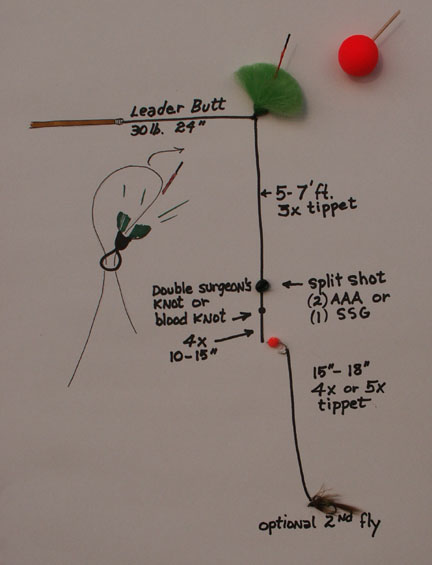
Sid: My first choice is Cortland's Camo intermediate full sinking line. For shallow water fishing, my choice is a greased floating line rather than a sink tip. I use sink tips for steelhead fishing, but I don't like them for stillwater fishing. They are heavier and less sensitive to feel. Plus they have that hinged effect. I much prefer a greased line for stillwaters. Basically, I just take an old dry line with cracks and add some abrasive action to the line by smearing it with silt or mud. The line sinks uniformly at about one inch per second and holds in the two to three foot target zone. It's an old steelhead method from the 40's that works great for shallow, stillwater nymphing. The clear advantage of the Greased Line Theory is the line does not spook fish like a floating line with a strike indicator. A strike indicator can spook fish right out of the area.

In between watching Sid land a number of trout in the 16 to 18-inch range, and quietly mutter to himself when he missed a number of really big fish, it was time to shift the interview to the waters at hand, the Williamson River. I spent two years building my house and shop so I had only fished the river three times. Each venture I caught two or three fish from sixteen inches to nineteen inches. Sitting low in the water in my one-man raft, I had not seen the enormous fish that I had seen on this day standing in Sid's drift boat. We glided by a rock formation that my son Brandon had fished the previous year. He had lost two or three really big fish in the run beneath the rock wall. When I pointed it out to Sid, he quietly informed me that it was a known spawning run and none of the guides ever fish it. I continued my interview.

Q: That spot will be off-limits to me as well. Let me begin with my most pressing question, when do the Klamath lake trout spawn, and when do they enter the Williamson River to escape the heat?

Sid: Spawning activity is sporadic and extends over a ten month period. Regarding when runs of new fish push up into the river, I've given up trying to find an answer. I've kept records trying to match surges with hatches, water temperatures and time periods, but I have found no corresponding factors that will predict when trout move out of the lake into the river system.

Q: I have been surprised to learn that fishing the Williamson River is similar to fishing the lake. It's basically stillwater tactics. Give me a summary statement to help get me started fishing the Williamson River.

River-V.jpg

Sid: I use a five weight rod. I have my clients use my G-Loomis GLX rods. They are more forgiving, and they have less line shock. I use Cortland's Intermediate Sinking line in the camouflage version. I use Orvis Mirage 6x fluorocarbon leaders. I mostly use Seaguar Brand Max fluorocarbon tippet material. Search out working fish and target them with the appropriate bugs, either nymphs or emergers. I interjected, "And be willing to spend two to three years perfecting one pattern, such as the Emphemerella doddsi."

Most of us claim to be passionate about some aspect of our lives, but it is only when we dedicate our lives to study and make a life-time commitment to learning everything we can about the passion that drives us do we attain the status of a master. Few of us achieve that level. Sid Mathis is a master fly fisherman.
Dave Archer

Free Spirit Guide Service, Klamath Falls, Oregon
Sid Mathis
(541) 884-3222
Email: sidmathis@aol.com

Crane Prarie Explored

| Comments

Redding, California - Oct. 25, 2007
The Sacramento River from Redding to Red Bluff

walk-bridge.jpg

So where does a former Montana fly fishing guide residing in Chiloquin, Oregon get his float fishing river fix. Perhaps the nearby Williamson River, maybe the Rogue or the Klamath or even the Trinity, but my choice will probably be the broad, big muscled lower Sacramento River. Flowing from the Keswick dam at the outlet of Lake Shasta, the lower Sacramento River flows through the town of Redding on its way to the San Francisco Bay. Miles of prime trout habitat line both sides of the river all the way down to Red Bluff. Offering four separate salmon runs, along with steelhead, the trout are healthy and fat. According to Michael Caranci, director of outfitters for The Fly Shop in Redding, California, when the dam operators were required to control flows and water temperatures to protect salmon runs and salmon fry, the trout benefited, and the fishing gets better year after year. I met with Michael at The Fly Shop, which may be seen from I-5 just north of the Churn Creek Exit. With October being their busiest month, Michael estimated they would finish the month with close to 400 trips. In spite of the hectic flow of anglers asking to book if there were any cancellations and the phone ringing constantly, Michael took the time to describe and promote the lower Sacramento River. I was impressed, but then maybe that is the reason The Fly Shop was voted the "Top Shop" by the fly fishing industry in 2003.

flyshop.gif

Two of the most productive months of the year are April and October. March and April basically kick off the season with prolific hydropsyche caddis hatches. The "Mother's Day Caddis Hatch" bursts on the scene blanketing the air with millions of bugs on warm, sunny days. Michael said, "The trout gorge themselves and eat, eat, eat, but the problem sometime becomes too many of the real thing surrounding an imitation." The caddis continue to hatch throughout the season and into the summer during the last hour of the day, which provides some good dry fly fishing. Many guides, in spite of the hatches, continue to fish under the surface with sparkle pupas, peeking caddis, Bird's Nest or bead-head nymphs in size 12 to 14, along with smaller emerger patterns. In May sporadic "hatches" of salmonflies appear through out the system but not on a predictable basis. Each year the salmonflies presence in the river grows.

driftboat.jpg

With rising temperatures of summer often exceeding 100 in July and August, the pressure of anglers on the river wanes, but the fish continue feeding in water temperatures from 55 to 60 degrees. I met a preacher working on his sermon on his tailgate at the Bonnyview Bridge near the water's edge. He said he liked fishing from his kick boat during the summer. With his legs submerged in cold water and his torso absorbing the hot rays of summer, he said he experiences heaven and hell in the same moment. He told me to emphasize to readers that sitting this close to the water was actually about ten degrees cooler. He said he keeps himself hydrated with lots of water and very busy with good fishing. Typically, however, the first and last hours are the most productive fishing of the day. By late August the nights are cooling and day time temperatures began dropping to the nineties.

waders-bridge.jpg

By September the first salmon runs appear. By October the salmon are busy building reds and kicking up debris and dislodging nymphs. The trout move in behind the spawning beds and feast on nymphs and the loose eggs that get washed downstream. Michael described it as "salmon omelets." Michael advised me to be especially vigilant when wading so as to not disturb or destroy the beds, which are easily identified by the light-colored depressions in the gravel. One successful technique to employ during October is a strike indicator, lead split-shot, a single egg pattern and one or two nymphs.

sac-setup.jpg

In spite of the increased pressure during October and November, guides spread themselves out over seventy miles. Michel stated thattypically by Thanksgiving or earlier the rains sweep up the valley and blow the river out below Cow and Cottonwood Creek, but it is rare that the upper stretch will be gone for more than a day or two at a time. That is actually one of the big assets of the Lower Sac, that it remains a viable fishery almost all winter long.". Most anglers wait for spring, but Michael pointed out that late winter on the lower Sacramento River offers good fishing between storm fronts. The latter part of the winter does not have the impact on water flows that November and December experience. Although air temperatures hold in the 50's and 60's and the fish slow in their feeding activity, more larger fish in the 18-inch range are caught during this time period with an added bonus of late winter baetis hatches. By early spring trout are gorging themselves on alevin, salmon fry, and gaining up to one pound a month from these tiny fish with the egg sacks still attached. If there is a dry fly period, it is in March and April when the caddis return and a new season is heralded.

To contact Michael and book a trip with The Fly Shop, you may reach him by phone at 1-800-669-3474 or at Michael@theflyshop.com or www.theflyshop.com

Launch Ramps and Access Points: Keep in mind that the time of year and the water levels flowing out of the dam determine whether wading is a viable option. Because the current is so strong, I recommend inflatable suspenders and a wading staff. For a detailed guide to the river, I recommend that you purchase the map, Sacramento River Fishing Access & Accommodations. The map may be purchased at The Fly Shop in Redding or by visiting their web site at www.streamtime.com. I welcome all scrutiny, corrections and advice, as this article will be a work in progress over the next year. Contact David Archer at dave@glaciertoyellowstone.com

2007 Shuttle Fees from The Fly Shop:
Posse Grounds as far as Sacramento RV Park...$25
Posse Grounds to Anderson...$30
As high as Bonnyview to Balls Ferry...$35
As high as SAC RV to the Barge Hole (Balls Ferry road near old mouth of Battle Creek)
...$40
As high as Balls Ferry to Jelly's...$45
As high as Balls Ferry to Bend Bridge...$50
Add map 1

posse-launch.jpg

map1.jpg

1. Posse Park Boat Launch + Wading: From I-5 take Highway 299 West and make a right onto Auditorium Drive (convention center). You may also reach the Posse Grounds from Cypress Street by turning north on Park Marina Drive, which ends at the convention center. This is the first launch past the A.C.I.D. Irrigation Dam a couple of miles below Lake Shasta's Keswick Dam. The launch site is behind the rodeo grounds near the convention center and provides good parking for all sized rigs and excellent access to Posse Riffle, as well as the numerous riffles and runs down to Redding's famous Sundial Bridge. During low water periods in the fall, wading anglers have numerous hot spots they may reach in a half mile stretch below the launch. During the summer months the numerous shaded, picnic spots provide welcome relief when temperatures climb to three digits. Turtle Bay Trail, across from the convention center and downstream from the launch, also provides access.

warn-sign.jpg

Two of Redding's bridges are under construction for the next couple of years. The river has restricted passages in two places.

cypress-restric.jpg

cypressbridge.jpg

2. Cypress Street Bridge Area: Exiting from I-5 onto Cypress Street in downtown Redding, move to the left lane and turn left on Hartnell at the light just short of crossing the bridge. This is a business section. Make the first right turn onto Henderson. Look for the sign "Road Ends 400 feet ahead." Turn right here and drive behind the businesses and park. Take the dirt path towards the Cypress Street bridge or turn downstream fifty yards and fish the riffle and pool by the old bridge abutment. This is a popular spot for the float fishing guides before they cross over and fish the western bank of the river. Crossing the bridge, anglers will find some water above and below the bridge.

bonnyview.jpg

3. South Bonnyview Road (Bridge) Launch: This is an excellent boat launch and parking area, although it doesn't provide good water for fly fishing in the near vicinity. From Posse launch to South Bonnyview is a half day float.

4. Cascade Park: Exit I-5 west on South Bonnyview Road. Turn left on Market Street or Highway 273 and then left again on Girvan and proceed a short distance to Cascade Park. I did not get far without waders. The park is adjacent to islands, although the channel was very shallow. South of the park is Niles Riffle, but I never made it - another time.

map2.jpg

5. Anderson River Park (launch): This is another spot that I missed. The Fly Shop provides maps to local wading spots, and this is one of them. South of Redding on I-5, take the Deschutes Road Exit (Factory Outlet Stores). Go west and turn left (north) on Balls Ferry Road and then right on Dodson Lane to Anderson River Park. Follow the trail down river for good riffles. An improved boat launch is located on Rupert Road, which may be accessed from a loop off Dodson Lane.

deschutes.jpg

6. Deschutes Road Bridge: From I-5 take the Deschutes Road Exit a couple of miles east to the Deschutes Road Bridge.

7. Balls Ferry Bridge (Bridge) Launch: From I-5 take the Gas Point Road Exit and follow Balls Ferry Road until it intersects with Ash Creek (sharp corner). Follow Ash Creek about a mile to the boat launch. (The bar here serves a good burger.) It is five miles to Cottonwood, a quaint little town close to I-5.

8. Reading Island: From I-5 take the Gas Point Road Exit and follow Balls Ferry Road until it intersects with Adobe Road. Turn right and proceed to the parking area less than two miles. Maps are not always accurate; the public campground has been closed by the county, and the launch is only good during high flows onto a side channel, and even then for smaller boats. Now, I did talk to a lady who lived close by and was walking her dog. She said she often sees fly fishermen casting on the main stem a short distance from the parking lot.

9. Old Mouth Battle Creek (Launch and primitive camping): The primitive camping is just that - primitive and rocky! Look for a drop off onto a dirt road. There are a couple of water holes to cross, but they are solid underneath. Nonetheless, after a rain this could be a potential mess without four wheel drive. The beach is hard packed cobblestone, and during October it is a popular spot for local salmon anglers (especially during the weekend). It is also a launch for boaters heading up to the Barge Hole just upstream. This section offers a beautiful riffle that left me frustrated and perplexed. I chalked it up to a full moon - not my skills! I talked to two neighborhood river watchers who said that during the caddis hatches the riffle comes alive with trout just at dark. From I-5 take the Jellys Ferry Road, cross the bridge and continue until you crest a plateau and see the river stretching out below you. From the crest, some anglers hike down to the river and fish Lawrence Riffle. As you drop off the crest down the slope, you will see on your left a long beach with a primitive boat launching spot. Just ahead on the left in the trees is the turn-off to this primitive site.

jellys.jpg

10. Jellys Ferry Bridge (Launch): From I-5 take the Jellys Ferry Road to the bridge and parking area and boat launch. (No camping.) This is a rough boat ramp; during low water periods you will be launching in wet sand and mud. I would recommend 4x4 vehicles after a rain. The site is run by the Department of Interior, but it does not allow camping.

bendlaunch.jpg


11. Bend Bridge (Launch): From I-5 take the Jellys Ferry Road Exit. Turn right on Bend Ferry Road by the Bend RV Park (916-527-6289) and store and cross the bridge to a county launch site. Fish the Lower Bend Riffle or take the trail on the north side of the parking lot to riffle water upstream.

bend-fence.jpg

bend-riffle.jpg

RV Camping Parks

jgw-rv.jpg

JGW RV Park: The JGW RV Park is located on Riverland Drive on the west side of Interstate-5, south of the Knighton Road exit. Exit 673 is approximately five miles south of Redding. (530) 365-7965. Reservations: 1 800-469-5910. www.jgwrvpark.com. Email: jgwrvpark@charter.net. (In the north corner of the park is a 5-strand, barb-wire fence. Go around it at the river's edge and walk upstream 100 yards to a great riffle, where I met a couple of fat rainbows. The resort provides a rough boat launch.

sac-rv.jpg

Sacramento River RV Resort: The Sacramento River RV Resort is located on Riverland Drive on the west side of Interstate-5, south of the Knighton Road exit next to JGW RV. Exit 673 is approximately five miles south of Redding. (530) 365-6402. www.sacramentoriverrvresort.com. Email info@sacramentoriverrvresort.com. Beautifully shaded, the resort offers a concrete boat launch for high water conditions and a dirt launch for low water conditions. Launch fees for non-guests is a bargain $3.

Marina RV Park: The Marina RV Park is located at 2615 Park Marina Drive. Although it is not a park like setting with lots of shade, it is within walking distance to restaurants and movie theaters. The launch fee for non-guests is $22.


Fishing in Sky Lakes Wilderness

| Comments

Straddling the Cascade divide between Four Mile Lake and Crater Lake, the Sky Lakes Wilderness encompasses 113,590 acres. Six miles wide and twenty-seven miles long, the lake basins provide almost 200 lakes, although most are shallow and do not support fish. Some of the lakes are more aptly described as shallow ponds, and the average size lake is between 30 and 40 acres. The largest lake is Fourmile Lake, which exceeds 900 acres and can be driven to from Highway 140. It is not surprising than that I would pack into this wilderness on two occasions with my two pack donkeys, Harley and Lately, and get skunked because I didn't do my homework.
me-boys.jpg

To check on stocking programs for the area, I learned from Dan Van Dyke at ODFW that a number of lakes are stocked with fingerlings every other year from helicopter. Of the Blue Canyon Group, Blue Canyon Lake, Carey Lake, and Horseshoe Lake are stocked. In the Seven Lakes Group, Alta Lake, Cliff Lake, Grass Lake, Ivern Lake and Middle Lake are also stocked every other year. Van Dyke went on to say that the growth of the fingerlings are slow, but it is not uncommon to catch rainbows and brooks up to seventeen inches with a string of moderate winters.

Statistics on the Lakes

Blue Canyon Group
Blue Canyon Lake - 2.5 acres; 18-feet depth; elevation 6,340
Carey Lake - 5 acres; 31-feet depth; elevation 6,020
Horseshoe Lake - 20 acres; 18-feet depth; elevation 5,230

Seven Lakes Group
Alta Lake - 32 acres; 13-feet depth; elevation 6,850
Cliff Lake - 10-acres; 15-feet depth; elevation 6,340
Grass Lake - 25 acres; 8-feet depth; elevation 6,040
Middle Lake - 20 acres; 12-feet depth; elevation 6,120

Van Dyke commented that Grass Lake typically held the largest fish, but they are known to be picky. Middle Lake took second place for fish size. Cliff Lake usually holds the smallest average sized fish, and the survival numbers go to Alta and Ivor Lakes. I also spoke to Jeff Von Kienast, wildlife biologist at the Prospect Ranger District. In years past both men have had good fishing in Grass Lake and Middle Lake. Jeff said that he had success fishing Middle Lake on the far side of the lake, and that a number of years ago he did very well at Grass Lake. Dan said that he took a number of Medford fly anglers into Grass Lake a few years ago and that anglers with float tubes did well while the shore anglers really struggled.
Grasslake-2.jpg

My first trip into the wilderness was from the trailhead at Fourmile Lake in early October, 2008. Our destination was Long Lake. We passed the first lake, and I noted that the shoreline was very shallow, and there was no way I could reach deeper water casting from shore. It was a harbinger of what was yet to come. Long Lake is beautiful, and we had a wonderful camping spot. From every elevated vantage point, I could see the shallow bottom for thirty yards and more. I never spotted a cruising fish. For two days and two evenings, I never spotted a rising fish. On October 25 I packed up the donkeys and headed into the Seven Lakes Basin.

This trip started out badly when I discovered the perverse machinations of the Forest Service. The Sevenmile Creek trailhead is two-fold - one for equestrian users and one for hikers. "No trailers beyond this point" read the sign, so I pulled into the equestrian trailhead parking lot. Towering above me was a steep mountain. Up and up we went traversing the switch backs to the crest. My mantra, taken from the children's book, The Little Engine that Could, began, "I think I can, I think I can, " and ended with sighs, coughs and grunts. Up over the ridge we went and spiraled down slope until I could see a sparkling spot of blue peeking through the dark forest. I was puzzled because I had only been hiking for fifty minutes, and my map showed no lake this early in the hike. Trudging down the trail, the forest thinned enough for me to see a dark blue Ford truck. Fifty-five minutes of hiking over a mountain top, and I had arrived at the hiker's trailhead!

Further in I met a hiker carrying a spinning outfit. He said that he had no luck at Grass Lake or Middle Lake, although he said that he had caught a few skinny fish at Cliff Lake. I camped at Grass Lake late that afternoon. From the hiker's trailhead, I made it to the lake in three hours, which included a 15 to 20 minute lunch break. The sign at Grass Lake pointed to the trailhead at 6.5 miles. Too pooped to fish, thanks to my extra hour of hiking, I studied the shoreline of Grass Lake and Middle Lake. Like Long Lake, the shoreline was very shallow, and I could see mud for thirty to forty yards. I never saw a rising fish that evening. The next morning I fished Middle Lake casting as far as I could, but I had no luck. The fact that I could not spot a single fish nagged me until I wondered if the severe winter of 2008 killed off a lot of fingerlings.
Buddy-Long.jpg

Dave Archer